Navionics+ U.S. North & Great Lakes • 010-C1368-30
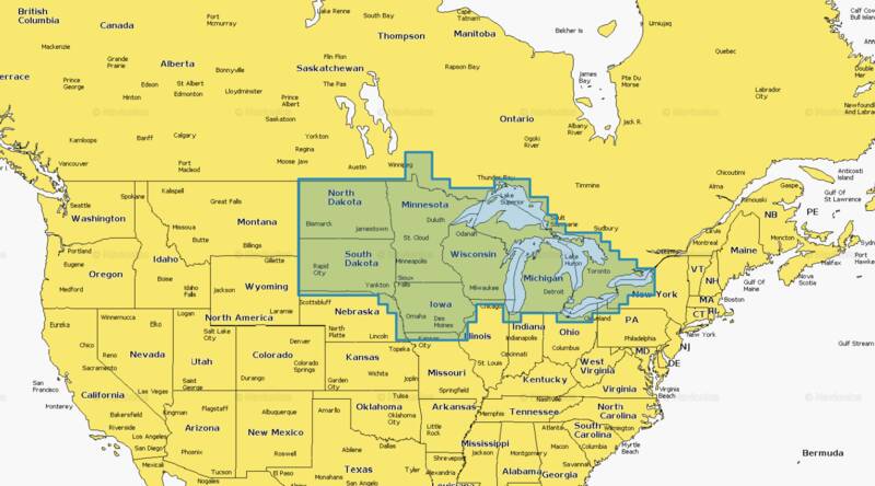

Detailed coverage of the lakes and rivers of Iowa, Michigan, Minnesota, North Dakota, South Dakota, Wisconsin, and the U.S. waters of the Great Lakes that border those states. Get the world"™s No. 1 choice in marine mapping "” with the best, most up-to-date Navionics®+ cartography on your compatible chartplotter. For offshore or inland waters, this all-in-one solution offers detail-rich integrated mapping of coastal waters, lakes, rivers, and more. Get SonarChart™ 1"™ (0.5 meters) HD bathymetry maps, advanced features such as dock-to-dock route guidance technology (depending on chartplotter model), live mapping, and Plotter Sync to provide wireless access to daily updates. The Navionics® Chart Installer software also ensures the freshest chart data every time out. Navionics route guidance solutions give you a suggested dock-to-dock path to follow through channels, inlets, marina entrances, and more. (Route guidance is for planning purposes only and does not replace safe navigation operations.) Multiple shading options aid in shallow water navigation and make it easy to highlight a target depth range for the best fishing spots.
- Opened packages will not be eligible for credit return
- Not compatible with Garmin devices
- Nautical Chart "“ Comprehensive charts are derived from multiple officials, government, and private sources, displayed in a familiar look and feel
- SonarChart HD Bathymetry - Innovative 1' (0.5 m) bathymetry charts are created by using Navionics proprietary systems that augment existing content with sonar data contributed by the boating community
- Community Edits - Get useful local knowledge from edits made by users of the Navionics Boating app on your compatible smart device.
- Daily Updates - Up to 5,000 daily updates to our charts give you the most accurate, most current Navionics data available.
- Dock-to-dock Route Guidance - Start your trip with a suggested path.
- SonarChart Live Mapping - Watch new HD depth maps develop in real-time as your boat moves through the water.
- Advanced Map Options - Customize your view to focus on the details that matter most
- Plotter Sync - Transfer routes and markers, update chart layers, and more - between your compatible chartplotter and the Boating app.
